• Don't want to see ads? Install an adblocker like uBlock Origin or use a Europe-based privacy-friendly browser like Vivaldi or Mullvad.

History Cool historical maps

Maciamo

Veteran member
Admin
Messages
10,632
Reaction score
4,461
Points
113
Location
Lothier
Ethnic group
Italo-celto-germanic
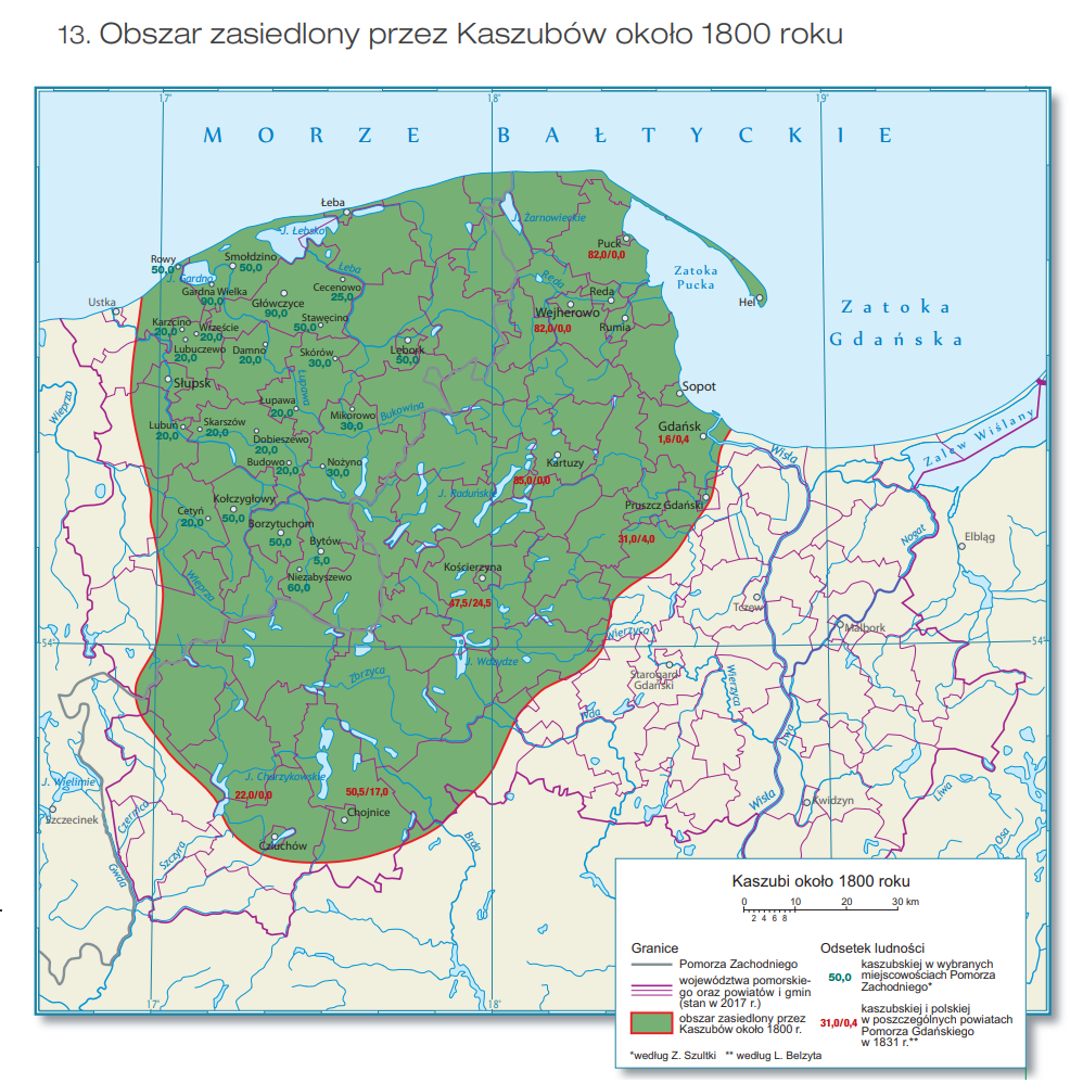
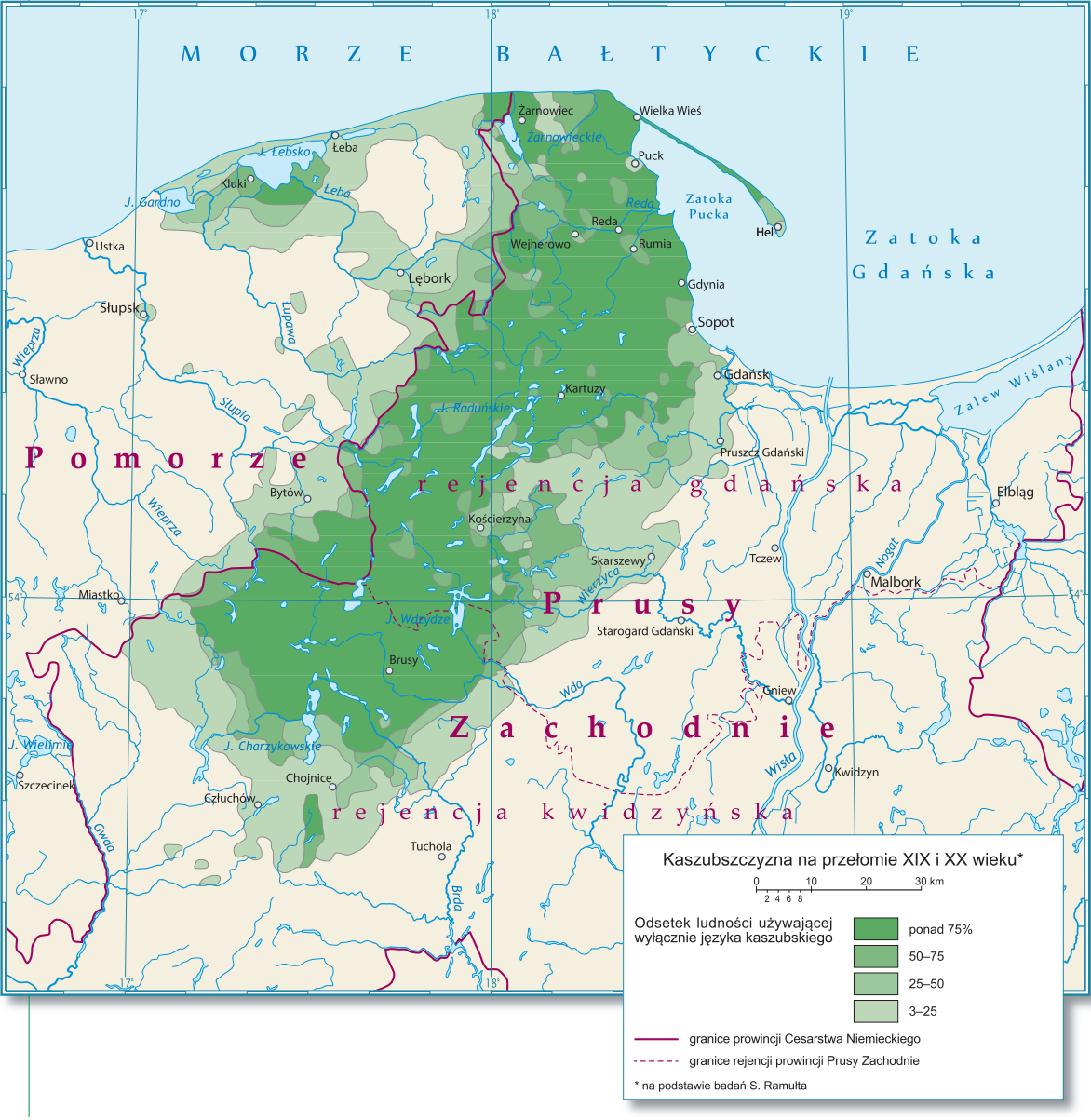
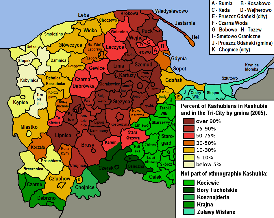
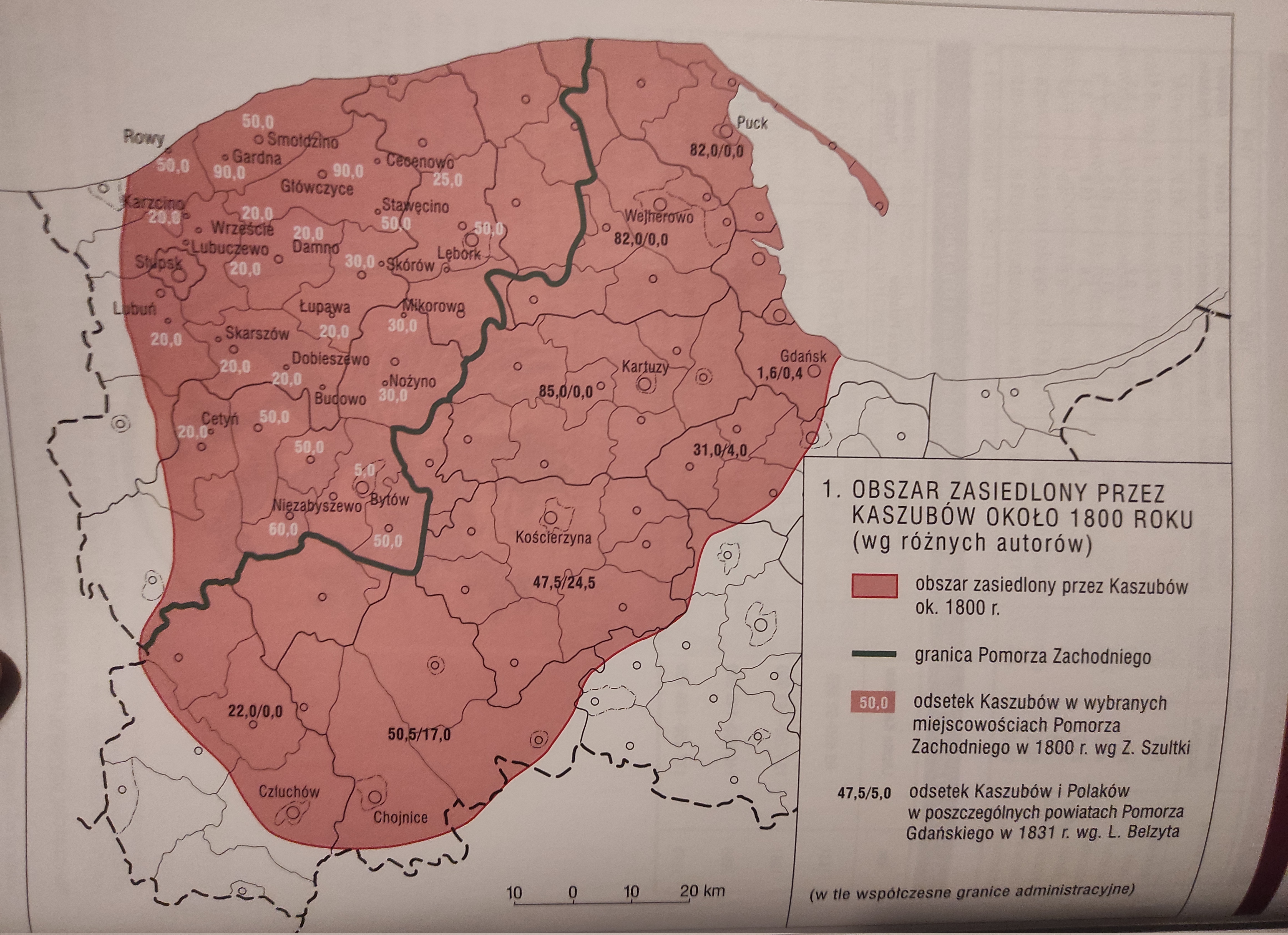
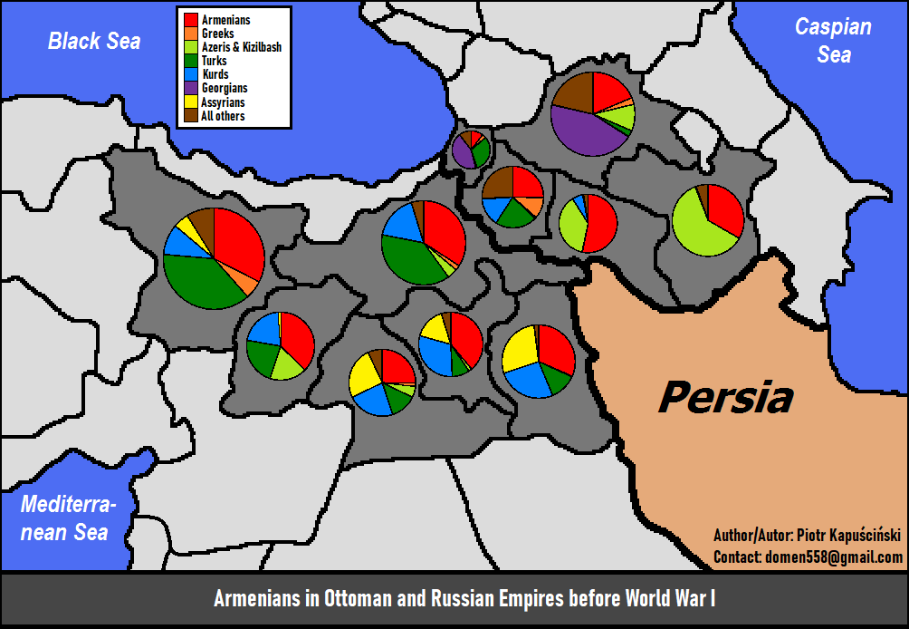
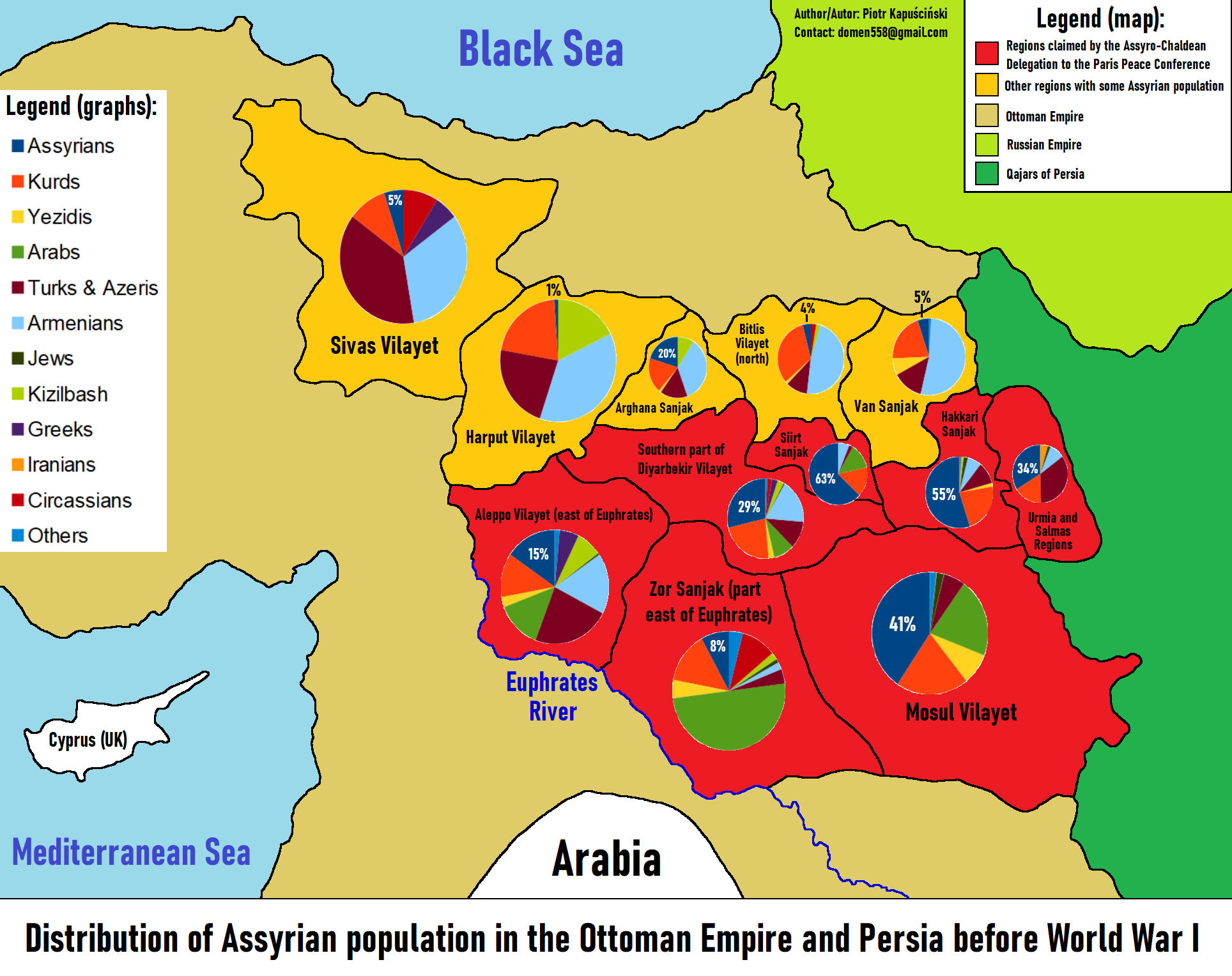
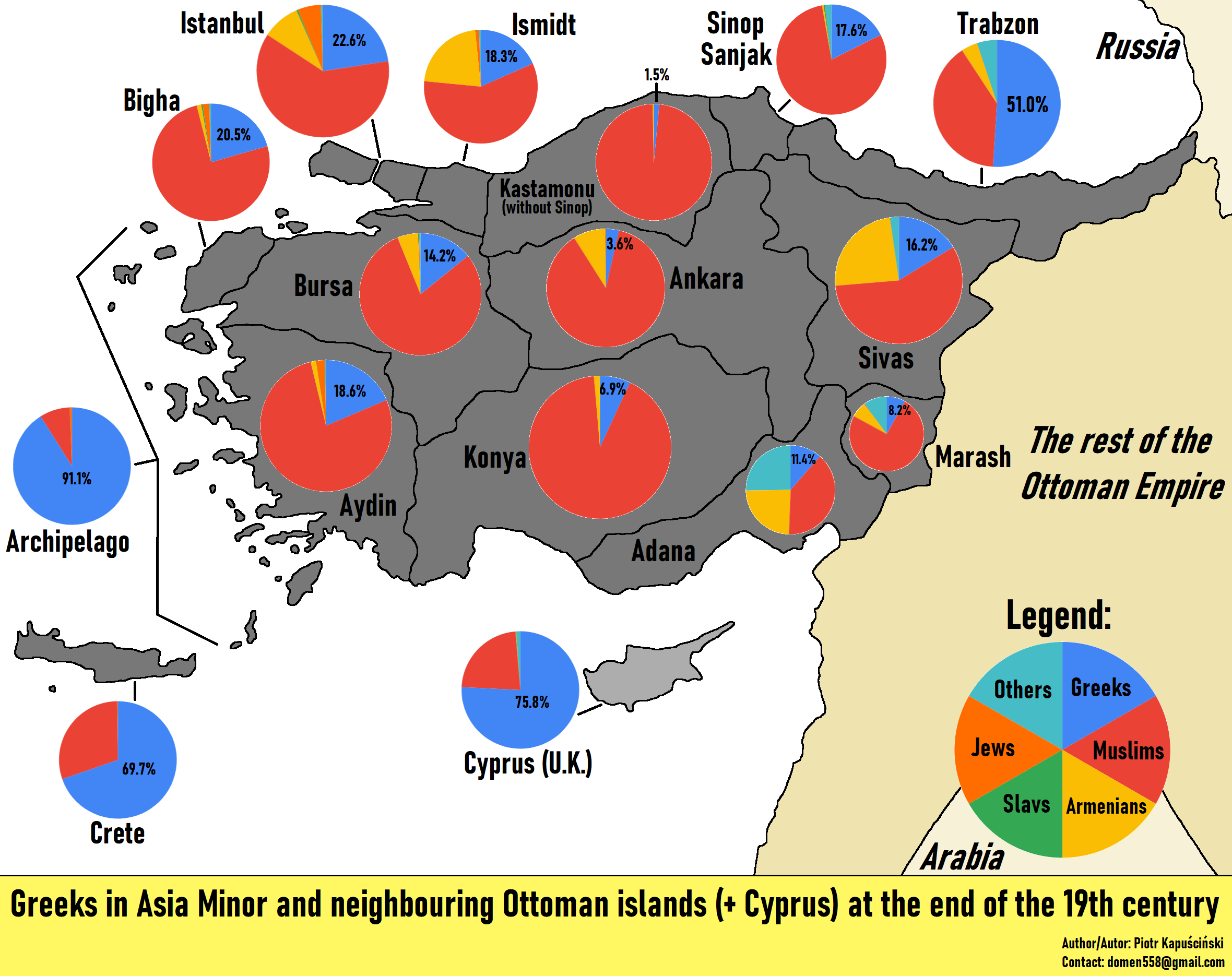
We already have a threat about interesting maps, but I thought I would start one specifically about historical maps as they are so many of them.

Map of Roman expansion


1000023232.jpg


Linguistic map of the Roman world at its height


1779179020448.jpeg


Linguistic map of Western Europe after the fall of the Roman Empire


1000023231.jpg


Kingdoms of Britain around 550 CE


1000023230.jpg


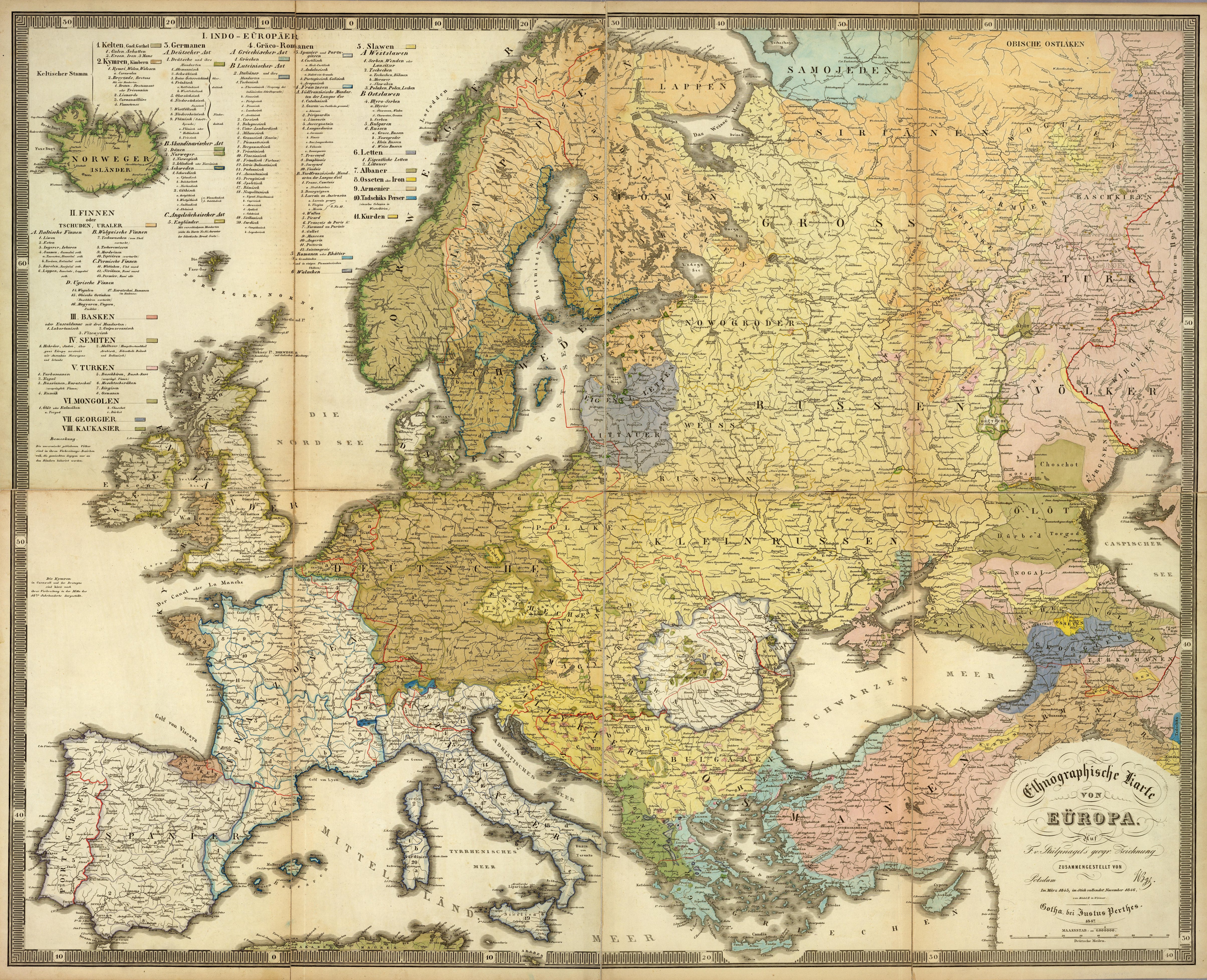
Linguistic map of Europe around 600 CE


1000023234.jpg


Linguistic map of Europe in 1815


1000023235.jpg
 
Last edited:

The waves of ancient Greek colonization from 750 to 450 BCE​


1000023237.jpg
 
Last edited:

Feudal France in 1032 (under the reign of Henry I of France)


Feudal_France.jpg


Holy Roman Empire during the reign of the Hohenstaufen Emperors (1138 – 1254)​

Holy_Roman_Empire-Hohenstaufen.png


For those who don't speak German:
  • Königrecih = Kingdom
  • HZT (Herzogtum) = Duchy
  • Fürstentum = Principality
  • MGFT (Markgrafschaft) = Magraviate
  • Pfalzgrafschaft = Palatine County
  • GFT (Grafschafshaft) = County
  • LGFT (Landgrafshaft) = Landgraviate
  • Erzbistum = Archbishopric
  • Bistum = Bishopric
 
Last edited:
Interesting maps! No area of Britain spoke Latin at the time of the fall of the Roman Empire?

BTW the "Holy Roman Empire during the Hohenstaufen Emperors" map has mistakes - Teutonic Order's State did not belong to the HRE, and neither did Pomerelia and Silesia. Silesia became part of the HRE only on 7 April 1348 (incorporated by Charles IV of Luxembourg).

Only because Prussia did not belong to the HRE is why Frederick I could proclaim himself as "King in Prussia" in year 1701.
Because inside the Holy Roman Empire, only the Emperor and the King of Bohemia were allowed to hold the title of "King".
 
Last edited:
Also the map of Europe's languages in 1815 shows Cassubian extending way too far to the south.

In fact it did not extend further south than Chojnice (Konitz) and Człuchów (Schlochau), while areas around towns such as Tczew, Skarszewy, Starogard and Tuchola were already inhabited by Poles speaking northern varieties of the Greater Polish dialect.

Here is a map of Kashubians in 1800 (including also areas where they were a large minority):

Kaszuby-1800.png


Kashubians around 1900 (since 1800 they lost some lands in the west to Germanization):

Kaszuby-Ramult-C.png


And here the distribution of Kashubians in 2005 (according to Jan Mordawski's research):

Kashubians-Map.png


And here is an old map of Europe's ethnic groups which was published in year 1847:
(it also has some inaccuracies, e.g. Poles seem underestimated in eastern terrritories)
(but the western border of Kashubians, although counted as part of Poles, is correct)

Mapa-Etniczna-1847.jpg
 
Last edited:
Here is Poland in years 1138 and 1250 according to a German Atlas WHKMLA:

KdZhDYH.png


And here you can see the border changes of Poland over 1000 years (my video):

 
Here a better version of that 1800 map of Kashubians:

(white percentages show % of Kashubians in various municipalities of Pomerania)
(black percentages show % of Kashubians / % of Poles in counties of West Prussia)

Kaszubi-1800.jpg
 
Migratory history of Iranian people since the Yamna culture.

Iranian_spread.gif
 
Percentage of illiteracy in Spain in 1877. Castile & Leon and La Rioja were the most educated regions by far.

1779870847808.jpeg
 
Number of fights and percentage for continents, from The role of soil in historical warfare: a review

"Europe accounts for the largest proportion of recorded battles (Miller, 2022), specifically 45%, with Asia following at 27% and North America at 14%. Lower percentages are observed in Africa (7%), South America (4%), and Oceania (1%)."
8SScx7B.jpg


"Indeed, as shown in Fig. 1, Europe displays the highest concentration of warfare events due to numerous factors (see infra and supra) that have consistently characterised the massive presence of conflicts in the 'Old Continent' (Pinker, 2012). Historically marked by numerous and heterogeneous ethnic and religious groups, the European continent has essentially been shaped by their often complex coexistence, frequently erupting into bloody and prolonged conflicts (Toft, 2009). This combination of conditions has historically made it a 'hotspot' for conflicts at every level (Diamond, 2017)."

"As Milligan (2022) has recently and cogently argued, such a distribution cannot disregard a fundamental aspect, such as its connection to a long historical tradition and an extensive presence of written historical sources. The 'Old Continent' boasts a wealth of ancient written historical records that have been preserved through a deeply rooted and well-established document archiving tradition; a reality that applies equally to its numerous diplomatic as well as military activities. Not least, a marked 'Eurocentric' influence in global historiography may have further exacerbated this pattern (Geraldo and Etnan, 2023).
No less significantly, Europe, with its long history marked by numerous conflicts, contributes significantly to the number of battles recorded in the dataset (Pinker, 2012). All this appears, as emphasised by Toft (2009), to be further complicated by the ethnic, religious, and power diversities that have always characterised the European continent, as well as by its strategic position (Diamond, 2017)."
 
Back
Top